top of page
SC State Capital Revolutionary War Painting

Kershaw

~ SC State Capital Revolutionary War Painting ~
This battle (1775 - 1783) was initiated by "
delegates" from the 13 colonies

(MA, NH, CT, RI, DE, NY, NJ, PA, VA, MD, NC, SC, GA)
in "congress" against Great Britain over the objection to Parliament's
Taxation policies and lack of Colonial Representation.

20200929_144253_edited.jpg

[Kershaw] where more than a dozen fierce Revolutionary War battles raged approximately two centuries ago. In 1732, English traders and farmers moved to the area from the Charleston coast...considered the oldest inland city (Camden) in the state.  The county (Kershaw) was created in 1791 from parts of Claremont, Lancaster, Fairfield, and Richland counties.

1785 1792.gif

In 1758 Joseph Kershaw, the “father of Camden,” established a store on Pinetree Creek, a Wateree tributary.

Located on the path between Charleston and the Catawba Nation, Kershaw’s store was a convenient place to collect and process local produce, especially wheat, before it was forwarded to Charleston.

Here the village of Pine Tree Hill developed as a milling and trading center.

Within a decade the thriving settlement was renamed in honor of Charles Pratt, Lord Camden, a champion of colonial rights, and a formal plan was drawn up to guide development.


In 1791 Camden was the second town in the state to be incorporated by the General Assembly.

During the Revolutionary War, British troops under Lord Cornwallis occupied Camden for nearly a year during their campaign to subdue the backcountry. 

20200929_145420.jpg

Among those imprisoned by the British in the Camden jail was the young Andrew Jackson.


Two major battles were fought near the town: the Battle of Camden on August 15–16, 1780, which saw a disastrous American defeat; and


the Battle of Hobkirk Hill on April 25, 1781, in which the victorious British suffered such heavy casualties that they withdrew from Camden a few weeks later.

The evacuating British destroyed much of the town, including its jail, flour mills, and several private homes.

Prosperity increased as the area’s plantation economy grew, based on cotton and slave labor.

Anxiety arose briefly among the white population in July 1816 when an alleged slave insurrection was uncovered.

Seventeen slaves were arrested and tried as ringleaders in the conspiracy, five of whom were convicted and executed.

Besides free whites and African slaves, a sizable free black community was present among the Camden citizenry by 1830.

The prosperous town entertained George Washington in 1791 and the Marquis de Lafayette in 1825.


Other arrivals helped the town progress further.


The Bank of Camden was organized in 1822, and a branch of the South Carolina Railroad reached Camden in 1848.

Source https://www.scencyclopedia.org/sce/entries/camden/

SC Election Districts Map #6

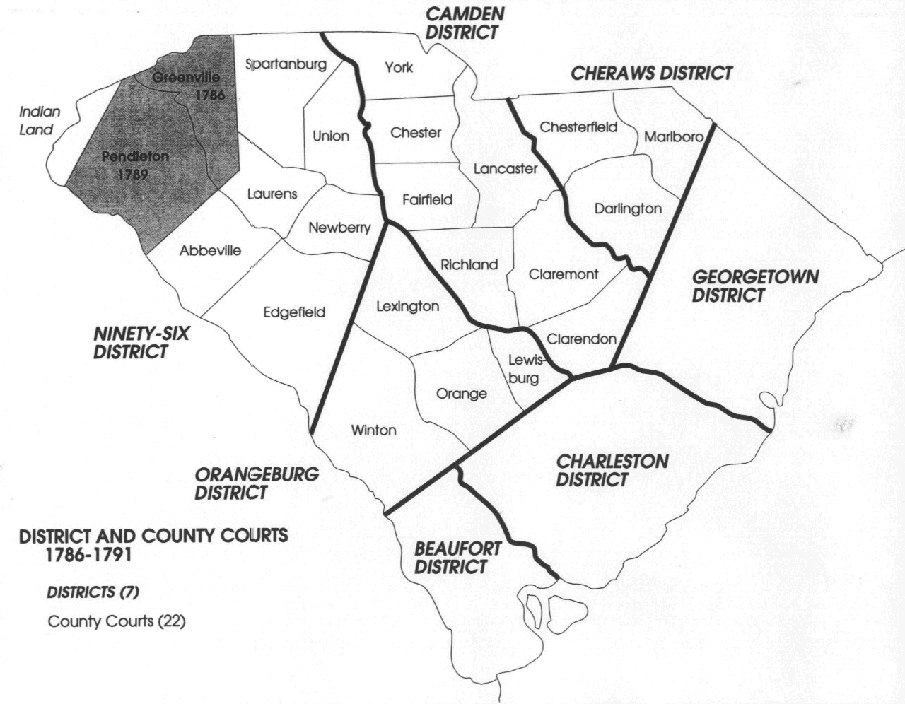
Reminder - in 1800, the South Carolina General Assembly abandoned the term "county" and all existing and new counties would be identified as "districts," combining judicial districts with election districts. The term district, in lieu of county, continued in South Carolina until after the Civil War.

During 1800, the Liberty District was renamed to the Marion District.


The Charleston District (equivalent to a county) was established, but it was not considered to be an "election district." Instead, seven (7) of the existing parishes, as shown above, continued as election districts to represent Charleston District.


The Colleton District (equivalent to a county) was also established, but it too was not considered to be an "election district." Instead, four (4) of the existing parishes, as shown above, continued as election districts to represent Colleton District.


The Beaufort District (equivalent to a county) was also established, but it too was not considered to be an "election district." Instead, three (3) of the existing parishes, as shown above, continued as election districts to represent Beaufort District.


The Orangeburg District (equivalent to a county) was also established, but it too was not considered to an "election district." Instead, three (3) of the existing parishes and districts, as shown above, continued as election districts to represent Orangeburg District.


The South Carolina General Assembly also created Barnwell District and Orangeburg District (equivalent to counties) in 1800, but they did not change the names of the existing election districts at this point in time.

The Sumter District (equivalent to a county) was also established, but it too was not considered to be an "election district." Instead, two (2) of the existing districts, as shown above, continued as election districts to represent Sumter District. Interestingly, Claremont County and Clarendon County were both abandoned (as were all counties), but they retained their "election district" status for years to come.

Joseph Kershaw
Kershaw 1800 Slave Owners.png
SC Election District Map #10

In 1855, the South Carolina General Assembly resurrected the old Clarendon District (was a county in 1785 to 1800) as the equivalent to all other counties (still called districts), and it retained its "election district" status, and it was no longer considered to be a subset of the Sumter District.


Sumter District was now comprised only of the Claremont "election district." In 1856, the District Seat of Sumter District was moved from Statesburg to a new town, aptly named Sumter Court House.


The old overarching Pendleton District was now only considered in the SC Senate, with a single Senator representing this district. The Anderson District and Pickens District were now their own "election districts" with their allocated delegates representing each district in the SC House of Representatives.

William Thomas Jeffers 1863-1915
Jeffers < Blaney < Elgin
Kershaw, SC

Fall Line Rd | US#1

Title
Sumter District, South Carolina
Names
Mills, Robert, 1781-1855.
Boykin, S. H.
Created / Published
[1825]
Headings
-  Sumter County (S.C.)--Maps, Manuscript
-  United States--South Carolina--Sumter County

See: 1820 Census [below] with M. Bracey & P. Bracey

Sumter Kershaw Richland_edited.jpg

1790 | 1st U.S. Census

1790 Census Heads of Family.png

1790 Census

William & Sackfield Bracey

[Brothers: see Virginia page for additional details]

1790 Census William Bracey.png

1800 Census

William Bracey

1800 William Bracey.png
1800 Census William Bracey_edited.jpg

1800 Census

Sackfield Bracey

[b1756 - d1807]

Great-Great-Great-Great Grandfather

1800 Sackfield Bracey.png
1800 Census Sackfield Bracey_edited.jpg

1810 Census

Mary "Polly" Bracey

[Mother of Sackfield Bracey | Wife of Randolf Bracey]

1810 Census

William Bracey

[Brother of Sackfield Bracey]

1820 Census

Lucy Bracey(wife) | Mary Bracey (mother)

of

Sackfield Bracey

1820 Census Wm Bracey slaves passed to 5 people_edited.jpg

1820 Census

Lucy Bracey

[b1768 - d1850]

1820 Census Lucy H Bracey wife of Sackfield Bracey.png
1820 Census Lucy Bracey wife of Sackfield_edited.jpg

1830 Census

Washington Bracey

Son of Sackfield & Lucy Bracey

now appears with 20 people listed as slaves

1830 Census Phillip Bracey 1 of 5 Bracey from 1820 census_edited.jpg

1830 Census

Washington Bracey

1840 Census

Lucy Bracey | 32 slaves

Washington Bracey | 7 slaves

1840 Census Ed and Lucy appear with Phillip and Washington.png

1840 Census

Washington Bracey

1850 Census

Washington Bracey

[Now has 2 children]

1860 | 8th U.S Census

[Instructions]

Pg 14, #5. Indians & Pg 15, #9. Color [below]

1860 Census

Washington Bracey

1870 | 9th U.S. Census

[Instructions]

Pg 10 Color [below]

1870 Census

Washington (father) & James (son) Bracey identified as [ I ] Indian (1860) census.
James identifies as  [M] Mulatto (1870) census ( the [ I ] Indian option no longer available) , and [W] White (1880). 
Henrietta would have been pregnant at 11 by 16 year old James [see above [1870 census].

James is married to Elizabeth by 1880.
Elizabeth would have been pregnant with their firs
t child at 20 (by 21 year old James).
At 27 & 29 James is expecting his 4th & 5th child from Elizabeth.
At 28 James "Jim" Bracey was expecting (or not) his 1st child (Israel Bracey) from
Sylvia "Slave" [prior slave owner Wm H Bracey].
[Sylvia's last name is listed as Frasia on the death certificate of son Isreal Bracey] 
The information provided on Isreal's death certificate (1926) is provided by Isreal Jr. to the best of his knowledge at that time (15 years after Sylvia's passing).

Birth Register

Sylvia Bracey

[b1853 - d1911]

1853 Sylvia Bracey Virginia U.S Birth Registers 1853 to1911.png
1853 Census Sylvia Bracey Birth Registers_edited.jpg

1880 Census

! 1890 Census !

[Most of the 1890 census population schedules were badly damaged

by a fire in the Commerce Department Building in January 1921.]

1900 Census

1910 Census

[Wife: Mary's name is misspelled "Motley", the document indicates married

16 years consistent with the prior ten year census which indicates 6 years] 

1920 Census

Isreal Bracey

Grandfather

Certificate of Birth GGrandfather CB_edited.jpg
Christopher Columbus Bracey

Father

Columbus Bracey
20200929_150120.jpg
bottom of page